I admit that I have been flying for quite a few years, and I also admit that the more I learn, the more I figure out that there is more than I will ever know. I treat flying as a constant learning experience, and as such, it makes life more interesting because it oftentimes stretches my comfort zone a bit. Stretching, in the end, feels good, so while I am naturally pretty cautious (and have also been trained that way for my entire aviation career), I get satisfaction out of feeling just a bit nervous when something new comes along. Such is the case when getting out of your home turf and experiencing new terrain and new environments.
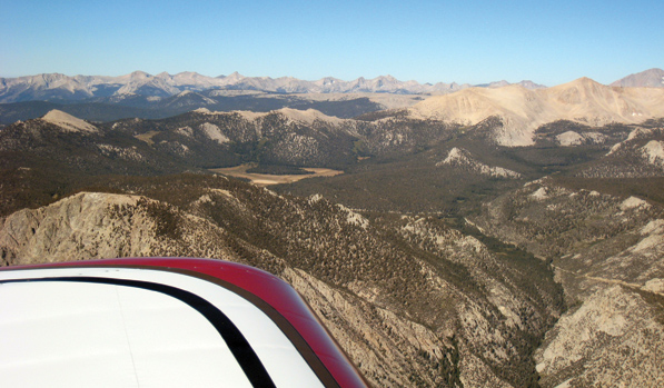
In the West, terrain takes on a whole other meaning to someone from the Midwest.
While I have traveled over most of the country in various airplanes, I can’t escape the fact that the vast majority of my hours have been accumulated in the flat central areas of the United States. Long cross-countries take me elsewhere, but my day-to-day flying occurs where the terrain elevation is 2000 MSL or less, and the relief rarely exceeds 500 feet. In more recent years, I have found myself headed west much more often, as my wife has a family cabin in the mountains of Southern California. Consequently, I am learning to undo years of habits, such as pushing the mixture to full rich before takeoff, and thinking that a climb to 10,000 feet is going to take some time (whereas, if you are starting out at 7000, it is amazing how quickly the level-off comes). Flying at low altitude off the beach over the ocean is no big deal, as long as you watch out for birds, but flying low over mountain ridges, forests and canyons is certainly an attention-getter to say the least, and something that I approach with great caution, even when I know the winds are calm.
In the Midwest, terrain warnings are most likely to be for grain silos.
Whether the Weather
Knowing the local weather is also something we tend to take for granted after enough years. I have been flying out of Houston for almost three decades now, and while I may not like the weather, I generally have a pretty good idea of what it is going to do under a certain set of conditions (it is always going to get worse). I can appreciate how someone who is not familiar with it may be wary of what a low morning might become, or how air mass thunderstorms forming in the summer afternoon are likely to be easy to navigate around (because they rarely move). I was reminded of just how important local weather knowledge was on one trip out west as we flew in to San Diego from Big Bear Lake (California) for a day of visiting family. For a while, I was reluctant to set out, and while I told myself that I was concerned about the traffic and airspace, what really had me worried was that I didn’t have a good sense of what the weather would do.
Our goal was a day flight to Montgomery Field, with a return after dinner (which, in the fall, means after dark). I like IFR, and I like night flying, and I like flying around the mountains more and more, but I am not thrilled about combining all three. Sometimes even two of these can be outside my comfort zone; I simply won’t launch into night IFR in a single, and will land early to avoid it. I have experienced the fog rolling in (they call it the marine layer out there, but it looks like low clouds and fog to me) around San Diego before, and I was a concerned that while the forecast for the evening was good, with nice visibility, there were also calls for broken clouds at 5000 feet, and scattered down lower. The fact that a VFR route out of San Diego’s Montgomery Field would launch me to the east, with its rising terrain, made me nervous about running into ceilings as the floor came up to smack me! I can hear the So Cal folks laughing at me now. I am sure they have a good understanding of what a particular forecast means, and what conditions will result. But that’s the point. They’ve been flying there for years, and have the local knowledge of what will be good or what will be bad.
In the Soup
Also on my mind were previous trips to Big Bear, where we flew west across the desert and saw nothing but clouds on the west side of Banning Pass. What I couldn’t figure out is how people could get up and down through that soup without an IFR clearance, and due to my unfamiliarity with the local airspace, navaids and procedures, I was reluctant to go that way unless I had no other choice. There are significant differences in the way various parts of the ATC system handle GA aircraft throughout the country, and while there is no doubt they all follow the same rules, and flights can be conducted safely, we can often stumble when confronted with local ways of doing things. I prefer to sneak up on them a little at a time, and not go charging off into strange airspace in IFR conditions only to get bombarded with strange place names and fixes. Again, outside my zone I guess.
It’s All Downhill from Here
After looking at the forecasts the night before, I finally decided that if it was good VFR with plenty of breaks, then there was no reason not to head “down the hill” if I could get out of the valley with good visibility. Good visibility? How about I could see to the moon! So out we went on a gorgeous day, and after crossing the dam at the end of the lake, we made the turn down the canyon and looked out over a beautiful LA basin covered in broken to scattered clouds. Sure, the visibility was not that great to the west, but heading south we had a wonderful ride, and the sky looked much like a sky anywhere in the Midwest, albeit with much more spectacular scenery.
The cloud bases allowed good clearance to terrain at all times, so we stayed up above 8000 feet until getting down near San Diego to duck under the Class B, cross over Gillespie and slide in to Montgomery. I had probably flown the route 10 times in my head before we ever left the ground, so we got about what we expected, but it sure was nice having a fully qualified pilot in the back seat watching for traffic and reporting points. It was a marvelously smooth day, and the 70 air was great as we visited the zoo and enjoyed the company of family. I see why people live in the area, despite the crowds.
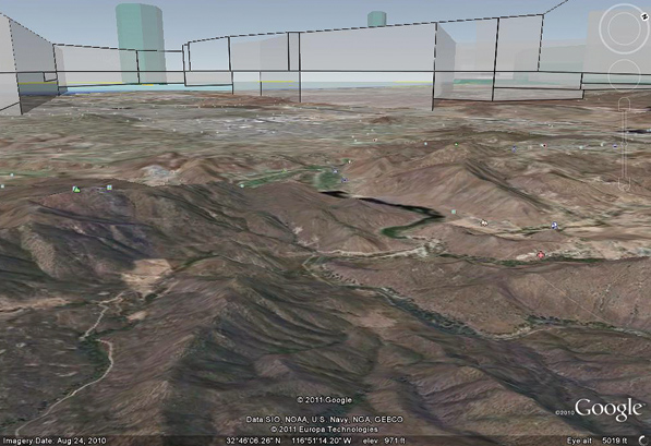
Google Earth shows the San Diego Class B area as a maze. Hey, who moved my cheese?
All afternoon I kept an eye on the sky, clouds and dew points. As sunset came, it was clear that there would be no marine layer, and the moon was close to full, so the flight back would be nice. The takeoff and right turn departure to the east brought a beautiful view of the city, and with airspace depicted on three different moving maps and the synthetic vision showing me the hills ahead, it was easy to enjoy the moonlit night, the climb to altitude and the cruise back up to Big Bear. Seeing the horizon line on the EFIS solidly above the mountains ahead as I approached the west end of Big Bear was a great comfort, and as the city came into view, the artificial glideslope led me down the lake to a nice touchdown in the cold mountain air, several hours after sunset.
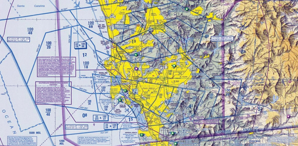
Most Class B areas in the country are circular. San Diego’s looks like it was hit by a truck.
As we taxied in to our hangar on the north side of the field, I popped the canopy and relaxed. I had been stretched a bit by the day’s activities, but I had approached it as a learning experience. I knew what I would do under all likely contingency cases (having full tanks could allow me a long retreat to the east), and having a good copilot I could bounce my thoughts and decisions off of made for a safe cockpit. Stretching can be fun, and the next time my wife, Louise, says, “Let’s go to San Diego,” it will be much easier to look at the forecast and know what to expect.


