In the spring of 2008, a five-year project finally took flight, the “Barry Marz Special,” our Van’s RV-10. It was a labor of love, created by a mechanic who really prefers creating to fixing (and prefers flying above all). He definitely built this airplane to fly it.
The four years post-build have been busy enough, and the cross-countries have been limited to a lot of flying in our region of the country (a big circle of 1000 miles or so). We had two kids in college and the economic slowdown to rein us in. There was one wonderful trip up the Eastern seaboard in the mix, and an assignment took me to San Diego from Florida. Those were both great stretches during which we could really examine what the airplane could do. And in both cases we made discoveries. The trip to San Diego convinced us to add electronic ignition to smooth lean-of-peak operations, and the trip to Vermont educated us on the crosswind limitations of the airplane. All need-to-know stuff.
This summer, with the kids graduated and the price of avgas slightly ameliorated, we decided to pull out the stops and finally take the “Great Circle” tour of the lower 48 states in our airplane. The excuse was that we needed transportation to get to Seattle for an anniversary cruise of the southeastern Alaskan coast. The reality was that we really wanted to fly ourselves there. Hey, we aren’t getting any younger, so why wait? No good objections were raised, so we were on our way.
There’s nothing like flying on perfectly blue VFR days. It is worth getting up early in the morning for this.
North to Alaska
Airnav.com helped us sort out where the most economical and logical fuel stops were along our route. Then a few calls to close friends cemented the track. Now all we had to do was hope for good weather. Sure, we could fly IFR, but we aren’t equipped for ice or high-altitude flight, so our options were somewhat limited.
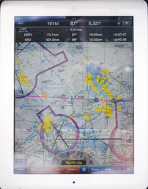
The iPad pretends to be a sectional chart (with benefits). It also does a great impression of an airport diagram and approach chart; the amount of information it holds is astounding. But in Yuma, Arizona, it temporarily shut itself down, citing an overtemp. A cool air vent aimed directly onto it for the rest of the flight worked to keep its core temperature down.
To fly a long cross-country anywhere from Florida, the first trick is always getting out of the state (have you noticed how long that peninsula is?). A tropical storm brewing in the Gulf of Mexico turned the consistently decent-in-the-morning weather into anything but decent. Having Navworx ADS-B weather onboard meant we could see where the real threats were in the clouds and avoid them.
First stop (not including a gas stop in Alabama) was Fort Scott, Kansas, where Airport Manager Kenny Howard was kind enough to put the airplane in the hangar, just in case, and loan us a crew car for the evening. With weather closing in, it was a great decision. We’d lost ADS-B coverage by then (or so we thought), finding ourselves in the “donut hole” of the not-quite-complete NextGen system.
Heading east just south of I-40 across Texas means at least one fuel stop. The RV-10 could go longer, but it was better to hit the weather ahead with full fuel tanks and more options. There was a headwind, even traveling east.
The next morning we headed out in marginal VFR conditions toward Rapid City, South Dakota, knowing there was a blob of bad thunderstorms out there somewhere. It was getting a little spooky, and then, whoa! The ADS-B was back and we could see exactly where the storms we wanted to avoid were lurking in the murk of four-mile visibility and 1500 AGL ceilings. It worked just long enough. One turn and we circumvented the problem, breaking out in full sunshine just an hour before landing at the gateway to the Black Hills.
It’s hard to believe that I’ve been to every state in the U.S. but never seen Mt. Rushmore. Done. The in-progress Crazy Horse memorial mountain carving was equally impressive, as were the crystalline blue skies of the western plains in summer.
We took off into that cloudless sky the next morning, heading for the mountains of Idaho, where our friends at Hendrick Manufacturing, producers of CNC-machined parts for kit and plans-built aircraft, have a 50-acre spread. The Black Hills quickly looked like small pickings as we carefully slid by the Grand Tetons and the Bitterroot Mountains, weaving our way to Bozeman, Montana, for a fuel stop. There, a few fair-weather scattered clouds broke up the sky, but nothing intimidating. We knew, however, that our next leg would include a couple of mountain passes, and we were still deep in the ADS-B donut hole, so there would be no help from there. We checked weather through Flight Service, but that only told us that the scattered layer would become broken to overcast when we hit the mountains. Precipitation? We called our friends on the other side of the hills. It wasn’t raining there, so we decided to try it.
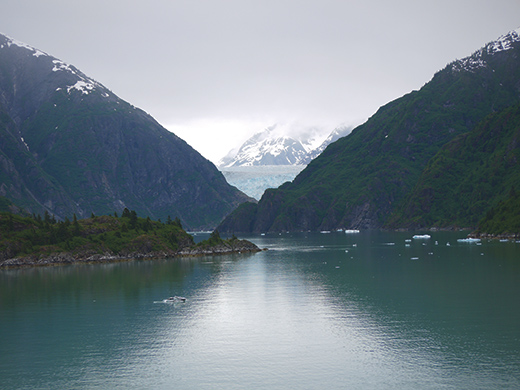
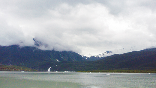
Sawyer Glacier, at the end of Tracy Arm fjord, draped in its perpetually cooling shroud of cloud. A helicopter could land there (and many do), but it’s tough for a plane.
The next thing I knew, I was looking out a windscreen pelted by…snow? We’d started through a pass that had looked clear under the overcast, and about halfway through…well, you know what happened. The snow quickly changed to light, then medium precipitation as we descended to avoid potential icing conditions. The Missoula airport loomed just around the next bend, and we chose to land to take a closer look at the showers that suddenly seemed to be surrounding us. Northstar Aviation (right next to Neptune Aviation, known for its firefighting prowess) was kind enough to loan us a crew car so we could go to lunch while we thought through our options.
It didn’t take a lot of math to figure out that we could drive the rest of the way to Orofino, Idaho, and still make it there that afternoon. Three days later, the skies cleared, just in time for us to come zigzagging down magnificent Highway 12 out of the Clearwater National Forest to reclaim our traveling machine and head out on the final leg, over the mountains to Seattle.
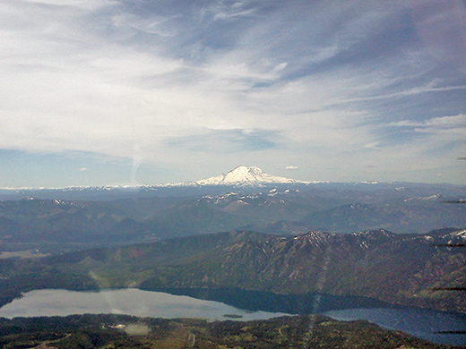
Mt. Rainier, the highest mountain in Washington and in the Cascade range, towers over the rest of the terrain for miles around.
Just for the record, I’ll remind anyone who doesn’t live and fly in the Northwest that Mt. Rainier is really tall. A 14,000-foot mountain can easily be seen on a clear day from 100 n.m. away, and I can tell you right now, I’d much rather fly when I can see that beast, even if I have a terrain database in the EFIS! We watched it grow in stature for the last hour of our trip, its classic volcano shape finally becoming clear up close, completely covered in snow, as we wove through Stampede Pass and into the green, gently rolling hills of the peninsulas and islands surrounding Puget Sound. Oh, and we got our ADS-B reception back the moment we cleared the mountains in Idaho. With stations blanketing the West Coast and southern United States, we never saw it drop off again.
We landed and taxied to a friend’s house at Crest Airpark, where a commercial flight-training operation and hangars share space with homeowners who operate from the airpark. It’s a nice combination that seems to work for all. A neighbor was kind enough to let us tie down for the week on his concrete pad. We patted the RV-10 on the nose and left for Alaska.
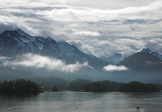
Southeast Alaska is stunningly beautiful, but the clouds drape the mountains nearly all day, every day. And then there is the cold rain. Not great flying weather if your goal is a scenic tour and you are in an aircraft that can’t hover or land on water.
Why didn’t we fly to Alaska? Just about every day of our cruise reminded us why: weather. It was mostly cloudy, with mist and light rain and temperatures that never reached 60. We saw aircraft operating, but they were mostly helicopters and seaplanes. The mountains we saw were magnificent, large and snow covered. Did I mention the snow? If we were going to stick to our policy of flying VFR near mountains (the better to see them, after all), we’d still be waiting to take off up there. It rains every day in the summer in Ketchikan, a kid from Juneau told me. After spending a few days along the coast, I think he was telling the truth.

Mendenhall Glacier (near Juneau, Alaska) from the ground.
Lake Mendenhall looks cold! (Note the icebergs floating on its surface.)
Homeward Bound
Our airplane was covered and content on its concrete pad in the lower 48. It even seemed happy to see us a week later (do machines smile?). We saddled up, and, instead of heading back the way we came, we traveled south to our old stomping grounds, Sonoma County, where we met more than a quarter century ago.
Flying south along the West Coast was a trip down memory lane. There was thick fog as we soared past Mt. Adams and Mt. Hood, and just as we crossed the border between Oregon and California, the mist lifted and there was the Pacific, the breeze kicking up whitecaps and big rollers. We cruised past Mt. Shasta, the last big volcano for a bit, and descended to 2000 AGL to savor the moment when the sunlight ricocheted off the golden dome of the Buddhist Shrine on the hilltop near Mendocino, finally turning inland at Jenner, following the Russian River to Graton and on into the Charles Schulz Sonoma County airport. It was a magnificent day for a homecoming flight.
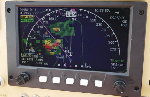
Navworx ADS-B on a GRT Horizon I EFIS shows a thunderstorm and the traffic avoiding it.
We stayed to enjoy the scenery with old friends, but eventually the real world called, and it was time to start heading east. Our first leg was a short one, just over one set of hills and across the Sacramento Valley to visit family for the 4th of July, and then we began the true test of the airplane’s capabilities: the long run home across the southwestern desert.
It was 96 in Yuma, Arizona, when we did a quick turn at Million Air. On takeoff, I pushed the nose forward to build speed past 140 knots to keep the engine cool, and the airplane just kept climbing, all the way to 7500 feet without busting 400 on the cylinders. Nice. Suppertime had us in Carlsbad, New Mexico, where Chandler Aviation took good care of us.
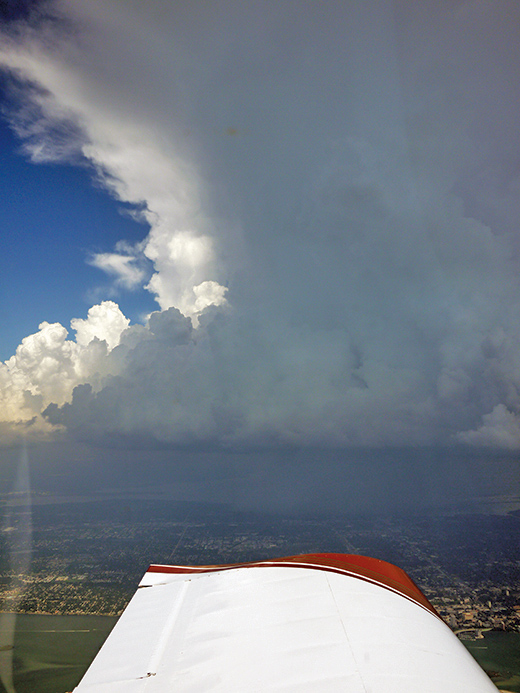
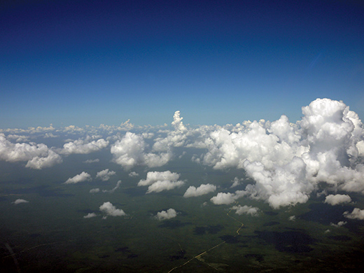
Near the Tampa Bay area, thunderstorms forced the flight path offshore.
The next day, we took off in the early morning out of Carlsbad and headed due east across Texas, stopping just briefly again for fuel at Rusk County (KRFI). This time the air was both humid and hot, but again the engine and its cooling system (a custom plenum) performed flawlessly. The next stop was Jackson Municipal Airport in Alabama. Not a soul in sight, but the self-serve worked and there were facilities for the, well, necessary human servicing, too. I’d put on decent catering (a soft-sided cooler full of yogurt, apples, salami, cheese and nuts), so we were out of there inside 15 minutes and back in the air, heading south and east this time. We climbed all the way to 11,500 MSL, topping the towering cumulus (for the moment). Two hours later, we were pushed offshore just to stay out of the clouds, which were rapidly maturing into full-blown afternoon thunderstorms. No matter. Our ADS-B showed that home was clear, and eventually we were able to turn inland and descend to our destination. We landed just under 8 hours after we’d left Carlsbad, having covered some 1500 miles. That’s not too bad for a hand-built airplane with just one engine and headwinds—yep, headwinds!
I’d do it all again in a heartbeat. After all, that’s what this airplane was designed and built for.

![]()
Amy Laboda has taught students how to fly in California, Texas, New York and Florida. She’s towed gliders, flown ultralights, wrestled with aerobatics and even dabbled in skydiving. She holds an Airline Transport Pilot rating, multi-engine and single-engine flight instructor ratings, as well as glider and rotorcraft (gyroplane) ratings. She’s helped with the build up of her Kitfox IV and RV-10.


