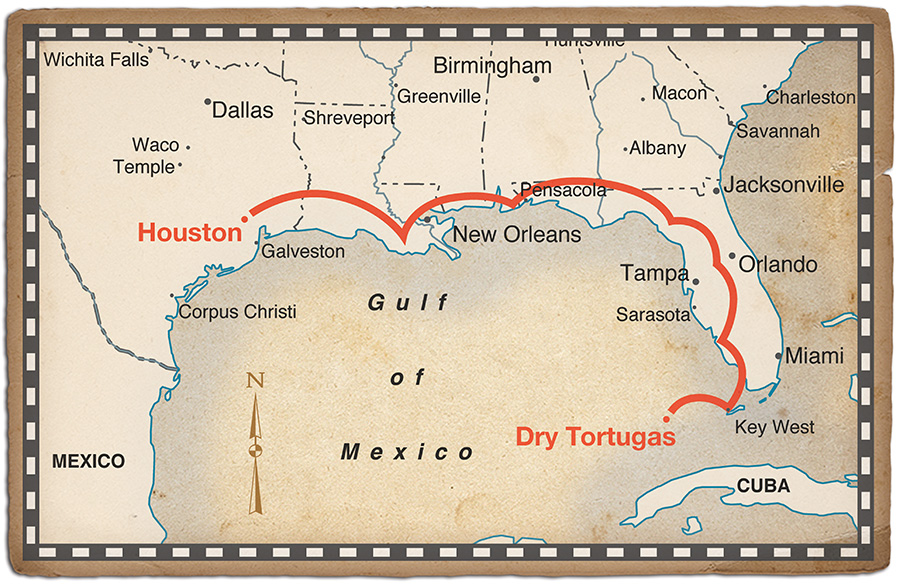
Houston was only an hour behind us, but the weather was turning out much worse than forecast. The ceilings were steadily lowering and the METAR updates said the few airports along our route were going from marginal to worse.
A pop-up IFR clearance would have been great, but there was a little problem: the airplane was equipped for day VFR only, with airspeed, altimeter and a little yaw string dancing on the windshield.
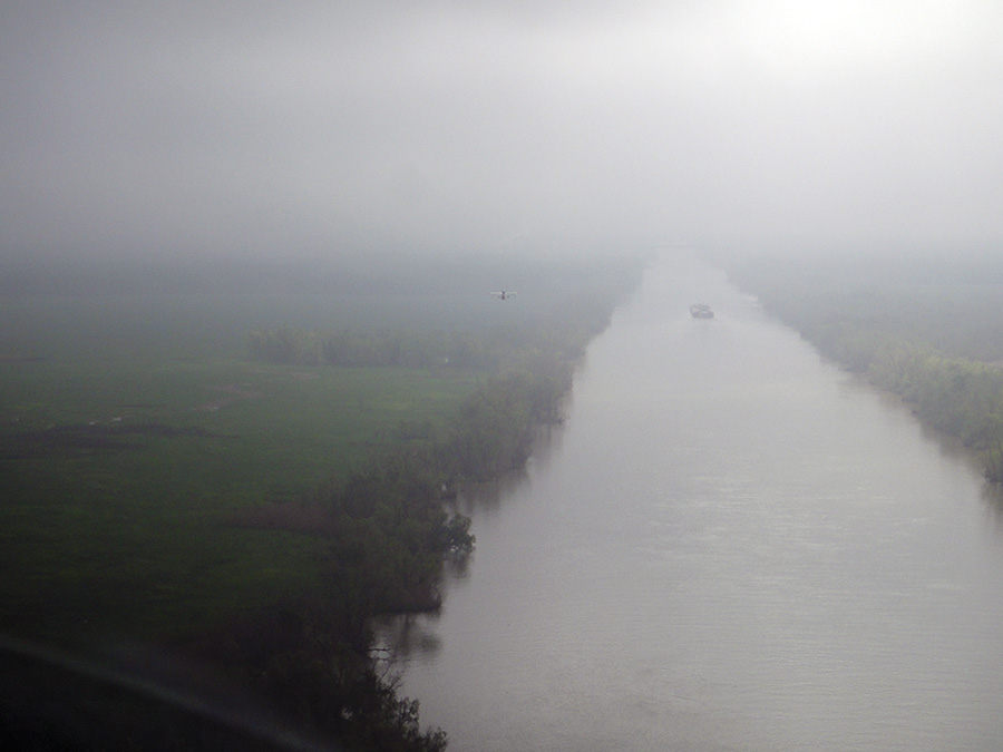
The clouds continued lowering, pushing us closer and closer to the Gulf Intracoastal Waterway below. Anjodi, Panache and Renaissance read the names on the barges as we passed overhead.
The journey.
In any other airplane, the pucker factor would have been off the scale, but we were a flight of two SeaReys en route to the Dry Tortugas and the waterway below was a 3000-mile-long runway, ready for us to bail out at any time.
With the deteriorating weather, there were only two good choices: continue following the ship channel or set down on the water and wait it out. Striking out across the Louisiana swamps didn’t seem like such a good idea; visibility could drop at any time, and without the smooth stretch of water below us, landing options would be limited. Visibility was sufficient to continue ahead, so on we flew, following the curve of the channel. It was a tortoise race between hope of improvement and the dropping fuel needle.
Building on a Dream
I am a visual person. Several years ago, I was thumbing through a magazine when a picture of Fort Jefferson jumped off the page, wrapped itself around my brain and seized my imagination. Pinned to the wall of the workshop, that picture was inspiration and motivation through 1,369 hours logged between opening the crate containing my brand new SeaRey kit aircraft and taking to the air.
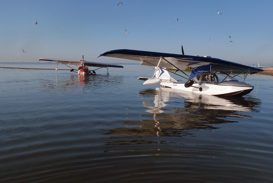
Some of my friends call me a serial offender. Others call me anal retentive. Those are the nicer descriptions. After building three airplanes, you’d think I’d be a bit faster, but I suppose that’s where the anal retentive part comes in. I’m just a slow, methodical builder. The Progressive Aerodyne SeaRey is a very complete kit. All parts come pre-drilled, pre-bent and anodized—like a big erector set that you mostly just bolt together. Of course, there are lots of time consuming details, like wiring, engine installation, and applying and painting the fabric (500 hrs for fabric and paint alone). They all added up to a lot more time for me to complete my project than many other builders. However, the finished airplane is all I’d hoped it would be—a lightweight (930 pounds), sprightly performer with a Rotax 914 that helps it jump off the water in just a few seconds, even with two people aboard.
It’s comforting to have an airplane that floats when the weather gets low.
Unfortunately, with all the flying wires, wing sponsons and the boat hull to push through the air, cruise speed is relaxed, to say the least. On a good day burning 5 gph, it will go a little faster than 90 mph. However, with a coarse pitch on the prop, it’s happy to cruise at around 70 mph, burning just over 3 gph, which is the setting most often used when playing in flooded gravel pits and bayous.
With 25 gallons of fuel capacity, the SeaRey will go for a lot longer than my bladder, but for this trip to the Dry Tortugas, we carried only 4 hours of fuel on each leg, to match the endurance of our partner SeaRey, piloted by Jim Garrett and his wife Roseann, who were flying with a Rotax 912 at a little over 80 mph and 4 gph.
Taking the Low Road
And so it was that we found ourselves humming along over the water in south Louisiana, watching the fuel level and clouds slowly drop, and wondering if we would get someplace where we could refuel, prior to one of them reaching zero. We could see on the GPS that Williams airport was within range, but we were reluctant to leave the security of the ship channel in such marginal conditions. Fortunately, there were two of us onboard the airplane, and one of us is beautiful, smart and resourceful (and not me). Better yet, she had discovered that the map on her iPad showed both the waterways and the location of airports in the area. As it turned out, there was a wet intersection just a few miles ahead, with a spur that ran right up beside Williams Memorial airport, where we could get fuel. Peering through the mists ahead, we counted down the miles to the intersection, watching the little airplane icon on the iPad getting closer and closer until—suddenly—there it was: a canal leading north, right where the map said it should be. Turning north, we followed it, and soon we could see the airport off our right wing. The FBO’s courtesy car took us to a nearby restaurant, where we happily waited for the weather to lift, marveling at how these amazing machines let us complete a flight that we wouldn’t have considered in most other airplanes. Despite the low clouds and visibility, with a current obstacles database on the GPS and sufficient visibility to see any towers, the flight was actually quite safe—we had a readily available out, which we could have taken at any time, had conditions deteriorated any further.
That being said, as we walked back to our airplanes in breaking sunshine, I was reminded of an FAA seminar where the presenter commented that most weather related accidents are investigated under sunny skies.
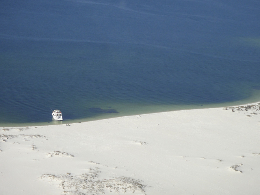
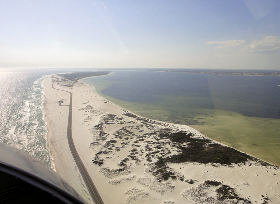
The powdery white sand near Destin, FL attracts boaters as well as seaplanes seeking solitude.
Eastward with Wi-Fi
Eastward from Louisiana, the controllers wanted us at a low altitude, and we obliged. Cruising in the warm sunshine with the engine humming happily behind me, I was engaged in careful study of one of the bikinis riding a parasail when the peace was shattered by my passenger shouting, “Yikes!”
Thinking my obvious gaze had given me away, I nervously looked across to find her smiling and tapping her iPad. “We have Wi-Fi!,” she declared with a triumphant flourish. It seems the beachside hotels in Destin have strong signals for their guests, and she had latched on long enough to email an update to her friends. Of course, it helped that the headwind had reduced our groundspeed to something that started with a five.
The shadows were starting to lengthen as we reached our destination for the first night, a cute little seaside town that provided hours of entertainment as we debated how to pronounce it: Apalachicola. The fine folks at the airport gave us a lift into town and recommended a hotel with a nice suite overlooking the marsh, along with a great local restaurant.
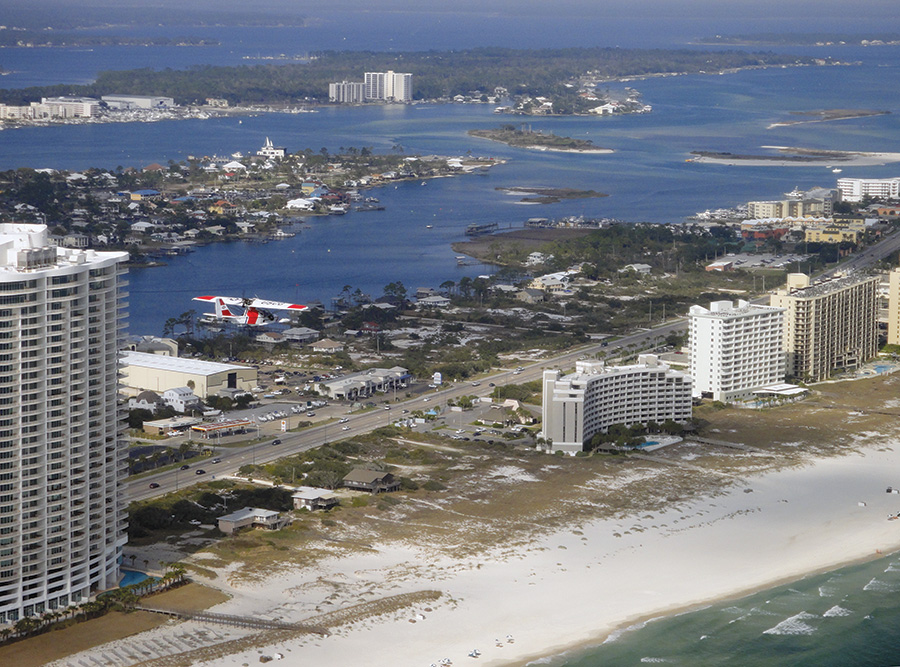
Florida beaches take on a different perspective from a seaplane.
Advantage—Hull!
Flying south of Naples, along the west coast of Florida, I was struck by how forbidding the terrain would be for any airplane relying solely on wheels. The Florida Everglades stretched as far as the eye could see on our left. The Gulf of Mexico was on our right, and below us was swampy shoreline with little in the way of roads or settlements. Even though we were in a flying boat, I still felt nervous as we left the tip of the mainland to strike out across open water for Marathon Key. If there was trouble, we wouldn’t be able to provide much more than moral support to each other. But I was still glad that we were a flight of two. At least if we had to do a forced splashdown, someone would know where the sharks were!
Seeing the Keys from the air is a tropical experience every pilot should have. Clear water, palm trees and sandy beaches presented postcard views every few minutes of flight. By the time we landed in Key West, it felt like we had achieved the pinnacle of our adventure; but more awaited us farther west.
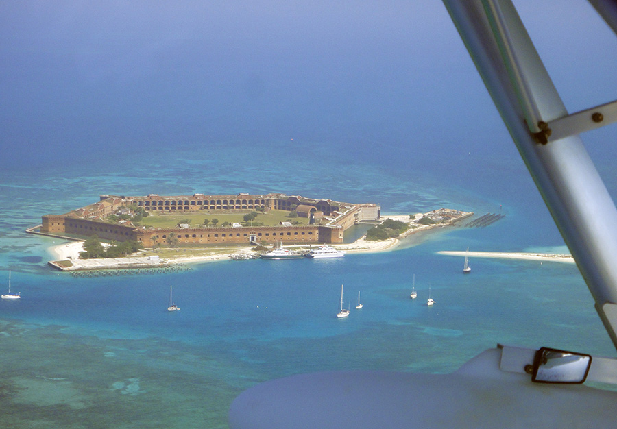
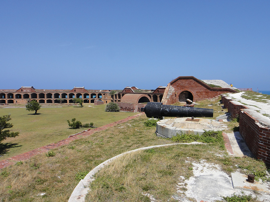
Fort Jefferson consumes nearly the entire island.
Preparing for the Tortugas
Flying to the Dry Tortugas is not simply a matter of hopping in and going. Prospective visitors cross the ADIZ (Air Defense Identification Zone) within a few miles of leaving Key West. As there is no airport in the Tortugas (or roads, or cars, or power lines, or houses), you can’t file a one-way flight plan. Instead, you file a special round-trip flight plan with a notation about stopping in the Tortugas. The flight plan is not actually closed until you return to Key West.
The Dry Tortugas are administered by the National Park Service, which requires a special permit for anyone wishing to land there. There are also sensitive wildlife (bird) areas immediately adjacent to the landing areas around the fort, which must be avoided. At the time we went, the permit cost $100 per plane and had to be obtained in advance of the trip. (Click for more information).
Located on the Key West airport, Key West Seaplane Adventures runs a regularly-scheduled floatplane service out to the Tortugas several times per day. We stopped by before departing and spoke to Evan, who was a great help in providing tips and tricks for landing at the Tortugas. He also gave us an up-to-date water and weather report from his first flight that morning, and told us about the NOAA buoy at the Tortugas, which is accessible over the Internet. These fine folks run a busy seaplane operation, but it is highly recommended to talk to them and coordinate before flying out to the Tortugas, as you will be sharing airspace and beachfront.
Westward to Adventure
After a day of resting and seeing the sights around Key West, we rose early the next morning and saddled up for the 60-mile flight to the Tortugas.
Oddly enough, I felt more comfortable on this leg than crossing to Marathon Key a few days before. Perhaps I was getting used to flying without any land in sight. Or maybe it was the fact that much of the route was over shallow, warm waters where we could see sea turtles gently paddling along. Of course, it helps that the Marquesas lie just west of Key West, so really there is only 20–30 minutes of honest-to-goodness, no-land-in-sight flying.
Actually hitting the Tortugas was an interesting exercise. We were pretty much relying on the GPS to take us there, but we were assuming that the blob on the GPS corresponding to the Tortugas was in fact placed correctly on the screen. It didn’t help that the blob on the iPad was in a slightly different place than the blob on the Garmin. Faced with slightly different locations, we split the difference and aimed for the middle. Sure enough, not long after leaving the Marquesas, someone shouted, “land ho!” and we adjusted course for Fort Jefferson to come into sight.
The Dry Tortugas actually consist of seven tiny islands, totaling just over 39 acres. Fort Jefferson very nearly consumes the entire island of Garden Key, which is perhaps not so surprising, when you consider that it is the largest masonry structure in the western hemisphere, constructed from over 16 million bricks. Construction of the fort started in 1846 and at its peak, was attended by nearly 2,000 soldiers and workers. It is designed to hold 410 heavy guns in its six external walls, each of which is three stories tall.
IFB (I Follow Beaches) is a great alternative to IFR! (I Follow Roads.)
The Tortugas have no fresh water and no vegetation to speak of, so everything to support the fort and its construction was brought in by ship, including all of the bricks, which were imported from factories along the east coast.
Originally intended to protect and control shipping in and out of the Gulf of Mexico, the fort became obsolete when cannons were developed that could penetrate its thick walls. By 1888, it was used as a quarantine station and, in 1935, it became a national monument until 1992, when it was designated as a National Park.
Gear Up for Landing
As we approached the fort, we could see that the wind and waves supported a landing along the eastern side of the fort. But the first order of business was to reconnoiter the area to make sure there were no hidden obstacles and to plan out exactly how we would get to the shore where mooring ropes would be waiting. An accident out here would be a major pain—the only boats were a few sailboats bobbing at anchor in the harbor and there certainly would be no shop facilities. Once again, I was happy to be in a flight of two—if anything went wrong, another experienced pilot and builder would be close by to lend a hand.
Coming around the wall of the fort on our final pass, we lined up on the azure waters along its western flank, dropping lower as we approached the calmer area provided by a protective spit. I was trying to time our touchdown to occur at the point where the waves were calmest and with sufficient room to slow down to taxi speed before reaching the spit. With a bit of luck, it all came together and, with a small skip, we settled into the warm blue waters of the Gulf and nosed up onto the powdery white beach. We had arrived! After three years of building and 17 hours of flying time, we finally reached our objective. As my toes wiggled into the warm sand, my mind filled with memories of long hours in the shop and the picture posted on the wall. In an instant, it was all worthwhile.
The fort is set up for self-guided tours, leaving us free to explore at our own pace, from ground level right up to the rooftops. In one room, we came across the cell of Dr. Samuel Mudd, who was imprisoned for treating John Wilkes Booth after Booth shot Abraham Lincoln. Mudd was pardoned in 1888, but his legacy lives on in the phrase for those whose reputation has been lost: “His name is Mudd.”
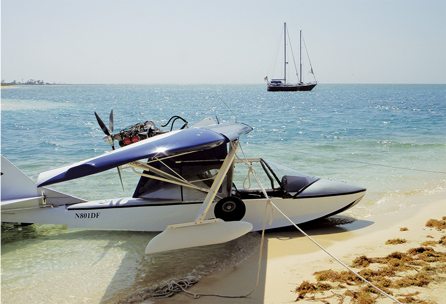
Originally intended to guard and control shipping in and out of the Gulf of Mexico, a lone cannon now guards only millions of bricks.
Aviating on Island Time
After touring the fort, we had a picnic lunch and laid out towels on the beach to enjoy a refreshing swim around the walls. After packing up, we flew back to Key West, where we enjoyed a couple of days touring the town, visiting art shops and enjoying the local food and sights before heading home.
Traveling cross country in an airplane like the SeaRey is not the fastest mode of transportation, but it gave us a unique, low-and-slow perspective of the country, along with sights, smells and experiences that couldn’t be obtained in any other way. It also allowed us to experience the thrill of landing our very own airplane on the water at an exotic destination. I feel privileged to be living in a time and place where an average person can build their own airplane and live an adventure like this.
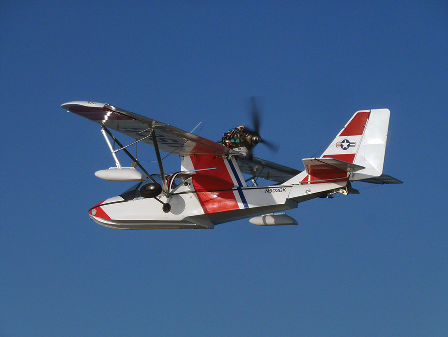
The SeaReys that Jim and I flew for this article are the original Experimental class SeaReys. Since our flight, Progressive Aerodyne has announced approval for the LSA version of the SeaRey. While the gross weights of our SeaReys allow them to be flown by someone with a Sport Pilot license, our aircraft are not the LSA versions. While the aircraft are closely related, there are a number of design differences between the two. Jim’s plane is painted as a tribute to the Coast Guard, just as many homebuilts wear warbird colors. For more information on the SeaRey, check out www.searey.com.
—D.F.


