![]() Smart Glide, which is Garmin’s newest built-in envelope protection, trickles down from the company’s Autoland. But unlike Autoland, it won’t land the airplane or fly a procedure on its own. Still, it’s smart enough to figure out which airports are within safe power-off gliding distance (and tell you when there aren’t any) and automatically navigate directly to the one of your choice. Better yet, an interfaced autopilot kicks the automation up another notch because it will automatically engage while nailing the best-glide airspeed while you sort things out.
Smart Glide, which is Garmin’s newest built-in envelope protection, trickles down from the company’s Autoland. But unlike Autoland, it won’t land the airplane or fly a procedure on its own. Still, it’s smart enough to figure out which airports are within safe power-off gliding distance (and tell you when there aren’t any) and automatically navigate directly to the one of your choice. Better yet, an interfaced autopilot kicks the automation up another notch because it will automatically engage while nailing the best-glide airspeed while you sort things out.
With the right compatible Garmin gear, the feature is easy to install with a field-loadable, no-charge software update. Here’s an overview of Smart Glide, which was Garmin’s big
announcement at AirVenture 2021.
Required Equipment
As we go to press in September 2021, Garmin was working on expanding the Smart Glide interface to work on more flight displays and GPS navigators. For the moment, you’ll need Garmin’s current GTN 750 Xi or GTN 650 Xi (legacy GNS and non-Xi navigators won’t work). Smart Glide won’t work with Garmin’s newer series of navigators, either, including the GNX 375, GNC 355 and GPS 175.
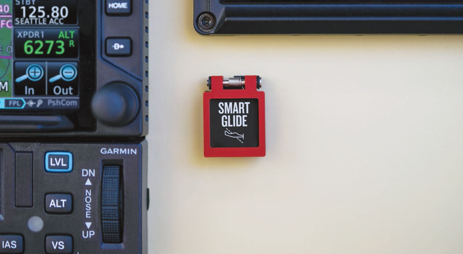
The main operating software containing the Smart Glide utility (version 20.20) is loaded directly into the navigators. Garmin doesn’t charge for the software, but you can expect an authorized Garmin dealer to bill out the time required to load the software, configure the GPS and do any required paperwork. This includes a revision to the navigator’s flight manual supplement, and Garmin also sells a $200 panel switch should you want one.
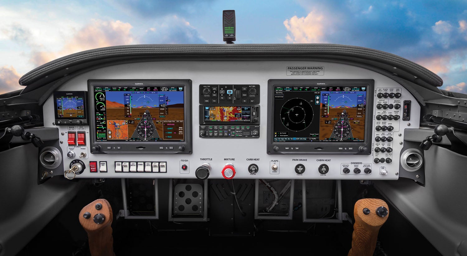
Since Smart Glide prompts the display of course guidance (for navigating to the airport), it requires a particular style of Garmin EFIS, which for now includes the TSO’d G500 TXi and GI 275 round-format electronic EHSI. By the time you read this, the interface could be functional with the G5 and the G3X Touch Experimental display. In that interface, you wouldn’t need an external navigator because the G3X Touch’s internal GPS would work, according to Garmin. These G5 and G3X Touch interfaces open up the Smart Glide interface to the Experimental market because, face it, there aren’t many kits flying around with TSO’d flight displays.
How It Works
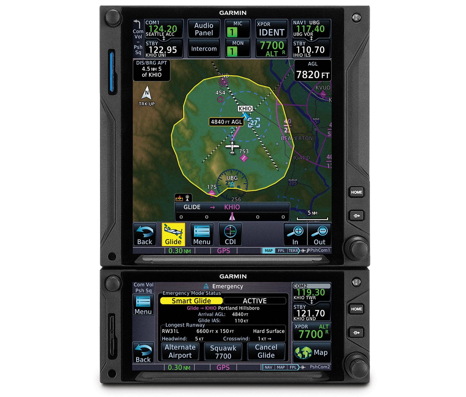
The driving idea behind Smart Glide is to immediately find the best suitable airfield(s) within gliding distance (and tell you when there are none). And it’s up to the pilot to engage the function by pressing the Smart Glide panel-mounted switch or by holding in the Direct-To button on the GPS for 3 seconds. The Smart Glide function is displayed as a dedicated menu option on the navigator’s Emergency page. With Smart Glide, two Xi navigators may be better than one for spreading all of the data out, especially since the Map page changes to a dedicated Smart Glide pictorial to better visualize the glide. There’s also an onscreen digital CDI that shows whether or not you’re on course.
Worth mentioning is that Smart Glide does not provide vertical guidance or automatic weather avoidance along the route, and it doesn’t provide altitude management. If you have an active flight plan in the navigator, as you almost always will if you are cruising en route, the existing flight plan will be replaced with a direct-to emergency glide path to the suitable landing airfield. (Smart Glide doesn’t work below 1000 feet agl after takeoff.) It automatically configures the navigator’s Map page to display a yellow range ring graphic that shows at-glance data on whether or not you’ll make the field, the topography below and arrival data based on performance and calculated winds.
Smart Glide takes the guesswork out of engine-out events by displaying the best-glide airspeed for the aircraft’s gross weight, and it also provides a list of alternate airfields within that glide capability. It’s good to have options, and it’s up to the pilot—not Smart Glide—to select one. The GPS offers plenty of valuable cues along the way, logically placed on the screen. For instance, the GTN 650 Xi’s Emergency page shows that Smart Glide is active and the Direct-To glide destination’s airport identifier as the active waypoint. A data field indicates the arrival altitude (agl), the targeted best-glide indicated airspeed, the longest available runway information, plus current wind information (headwind and crosswind components, for example) as received from a compatible connected weather receiver.
Speaking of connected equipment, regardless of whether you can glide to an airport or not, Smart Glide automatically tunes the GTN’s com radio to the appropriate tower or CTAF frequency, and when interfaced with a Garmin transponder, provides an onscreen softkey for a one-press activation of the 7700 squawk code. The reason Smart Glide requires a compatible external nav indicator (EHSI) is for nav course display, and it automatically changes the CDI scaling to 0.30 nautical miles as it tightens up the GPS course guidance for navigating to the field. Since there may be more than one choice for landing, airfields are prioritized (or ranked) based on weather conditions and configured runway lengths. Again, you’ll need a functioning weather receiver for prioritizing IFR, MVFR or VFR airports. When it comes time to configure the data, we suggest you’re present and play an active role with the shop doing the install. Please don’t rely on them to get the correct data entered for your particular aircraft.
During a Smart Glide activation, the priority is getting the airplane on the ground immediately, so a lot of the data that you previously had configured on the screen is removed. This includes fuel range rings, electronic chart overlay, airways and NEXRAD weather images. Again, two screens will be better than one because you might choose to display Smart Glide on one and non-emergency data on the other.
Autopilot Interface
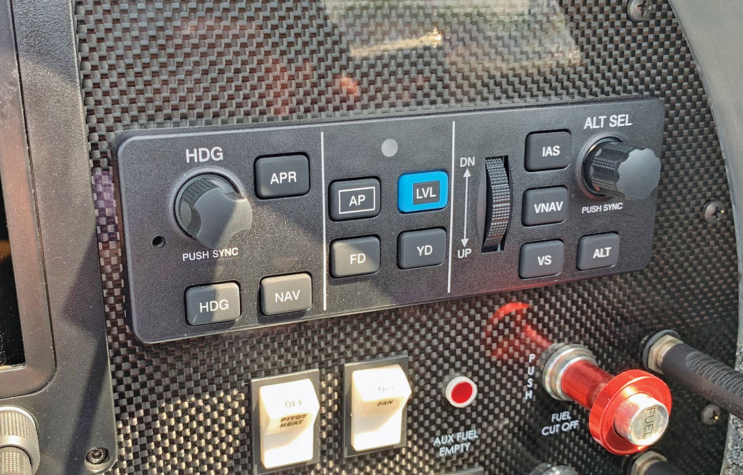
Smart Glide doesn’t need an autopilot, but with Garmin’s GFC 500 (and select vintage TruTrak systems) the feature gets a boost in utility. When Smart Glide is engaged, it also engages the autopilot servos and makes good use of the GFC’s airspeed hold by capturing and holding the preselected best-glide airspeed. You’ll also see the flight
director command bars pitch for the best-glide attitude, and the autopilot will track to the destination airfield.
Remember, Smart Glide doesn’t provide vertical capturing, so the autopilot won’t automatically fly a visual approach, and it won’t automatically capture a localizer. But Smart Glide draws an extended centerline off the runway to line up with and track in for a landing. You could also load the visual approach procedure in the navigator (and an instrument procedure, too), but that will override Smart Glide guidance.
You’ll want to configure the aircraft early with flap setting and landing gear position because the computed glide ratio has an approximate 30-second stabilization period. In other words, drastically changing the pitch configuration of the aircraft could cause the system to recompute the new glide ratio, burning critical time. This is a good argument for an autopilot interface because it will hold the best-glide airspeed.
Smart Glide offers decent visual cues as you maneuver the aircraft into the airport environment. There are flashing textual annunciators displayed as a banner on the Emergency page (and over the route page on the navigator’s Map page), which advises the pilot of warning, caution and advisory conditions. For example, an advisory alert is white text over a black box that tells you when you’re 4 nautical miles out and approaching the airport, a textual caution alert tells you if you won’t make the airport, and when you’re within 2 miles of the runway, a “Maneuver and Land” warning message tells you so.
Conclusion
We have to wonder how the Smart Glide technology can evolve into a more automated interface, and that includes actually landing the airplane—or perhaps flying it into the landing flare as you sit and watch. The Experimental market could be the best place to test those waters. We also hope Garmin expands the interface to work with third-party displays and more Garmin GPS models. At press time, Garmin said it was working on that, and we’ll keep tabs on the interface as it grows.
![[Credit: Lisa Turner]](https://www.kitplanes.com/wp-content/uploads/2026/04/Inspections-1-scaled.jpg?w=218&h=150&crop=1 "Last Bits")
![[Credit: JetStream Rider]](https://www.kitplanes.com/wp-content/uploads/2026/04/AdobeStock_345999332.jpg?w=218&h=150&crop=1 "2026 Avionics and Lights Buyer’s Guide")
![[Credit: Dynon]](https://www.kitplanes.com/wp-content/uploads/2026/04/EMS-stand-alone_HDX.png?w=218&h=150&crop=1 "Dynon Unveils Scalable Engine Monitoring for Kitbuilders")
![[Credit: Eric Powell]](https://www.kitplanes.com/wp-content/uploads/2026/02/AdobeStock_1043661239-scaled.jpeg?w=218&h=150&crop=1 "Weight In The Balance")


Xavion already does this, correct? It is too bad they are not mentioned. It would be interesting to hear how they differ.
Comments are closed.