So, we’ve got this huge furnace about 94 million miles away from us, and we want to tap into that furnace’s power. Since this furnace is “burning” about one trillion one-megaton hydrogen bombs per second (about 500 trillion trillion [5 x 1026] watts per second), it seems reasonable that even at 94 million miles away, we ought to be able to get a little tiny bit of that power to light our hangar and run a few small tools.
So how much power per square foot does that equate to on the surface of Earth? Roughly 60 watts of infrared, 50 watts of visible, and 4 watts of ultraviolet. But the lower end of the spectrum (infrared) doesn’t have enough energy to knock those electrons around to produce power, and the higher end of the spectrum does a Babe Ruth and knocks the electrons so far out of the ballpark they don’t produce power either. It is the visible (and tilted towards the high, or blue-violet, end) that produces the power.
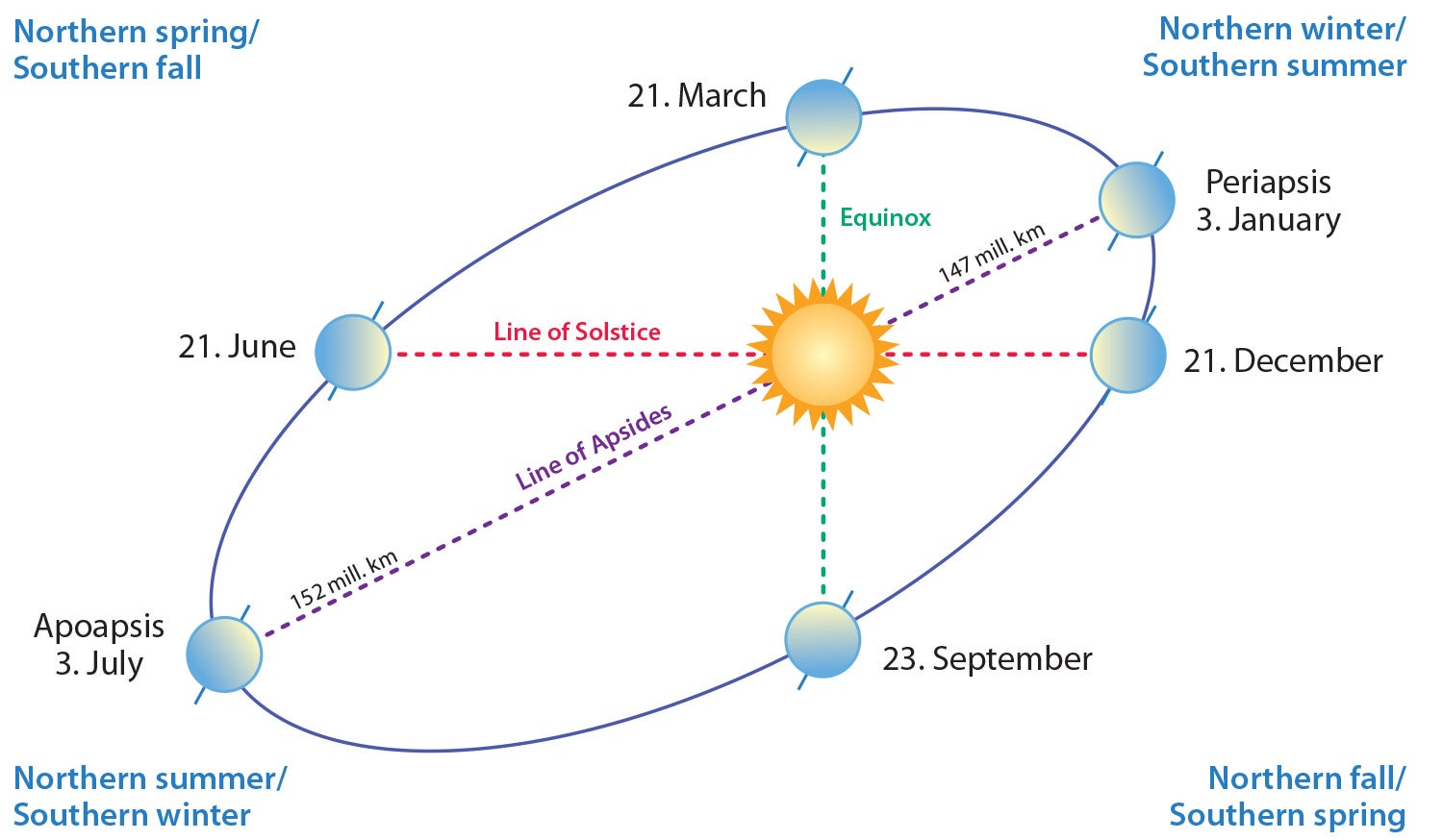
A few more problems to consider: The earth does not have a circular orbit around the sun—it is elliptical. Also, the earth is tilted so that it is about 24° relative to its orbit. It is closer to the sun in the (northern hemisphere) winter and farther away in the summer. Our colleagues south of the equator can get a fair amount more solar power than we can in the summer, but then again, their summers are significantly hotter than ours are, and they get less power in the winter.
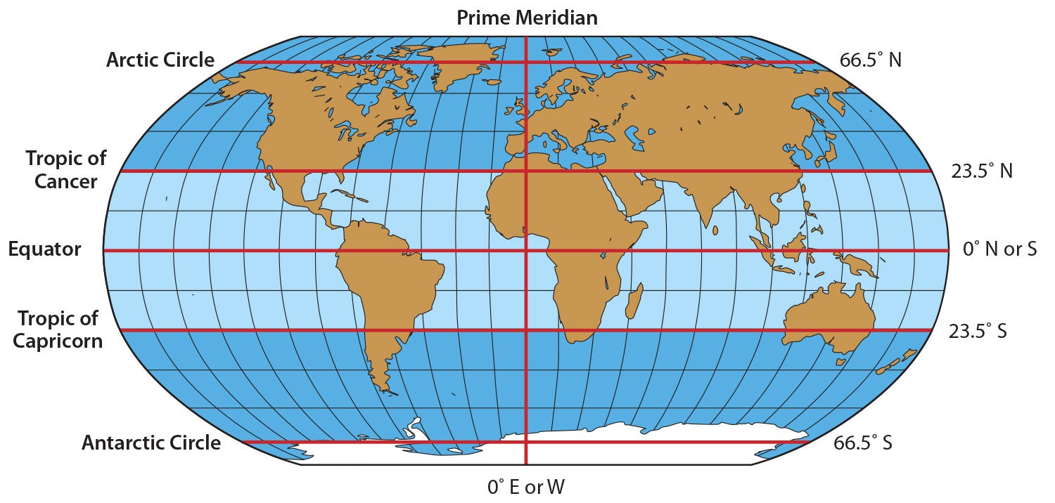
The sun traces out a sine wave between the Tropic of Cancer (a line of latitude 23.5° north of the equator just ticking the Florida Keys) and the Tropic of Capricorn (a similar line south of the Equator slicing Australia in almost perfect half. It just touches Cancer on June 21 and swings south to Capricorn on December 21, thus defining the first day of winter and the first day of summer, also called by scientists the winter and summer solstice. (Solstice means “the sun stands still,” which it does for that one day directly over Cancer and Capricorn.)
OK, enough of the theory; let’s get to the point: Unless you sit on your roof with a micrometer and a very seriously gimbaled solar cell mechanism all day, every day, you will never get perfect insolation.
Insolation is the measure of how much power falls per square foot and how much of the possible power does the solar cell actually produce. For example, in the winter everybody has to pitch their solar cells up from 0° (flat on the roof) to some rather large number to point them at the winter sun low on the southern horizon. If you kept that pitch angle constant, you would lose a lot of the direct summer sun when the sun is much higher in the sky during the day.
The purist would say that to get absolutely every bit of energy that Old Sol is sending us, you would have to continuously keep readjusting the pitch angle and the pointing angle all day, every day, forever. Isn’t going to happen. With reasonable compromises, we can get about 75% of that power all day, every day.
I’m going to present three choices for pitch angle (next column) and one choice for pointing angle, and I’m going to discuss pointing angle first.
As we all know, the sun rises in the east and sets in the west. One of my Wisconsin buddies told me that this is the waffle rule: “Da waffle rises in der yeast, and sets behind der vest.” Be that as it may, we need to point our solar cell directly to the south to get the maximum insolation. Remember, the sun has absolutely no idea where the earth’s magnetic pole is. It shines directly on the true north and true south poles. How can we tell where true north and south are? We’ll use some simple math and a few tricks.
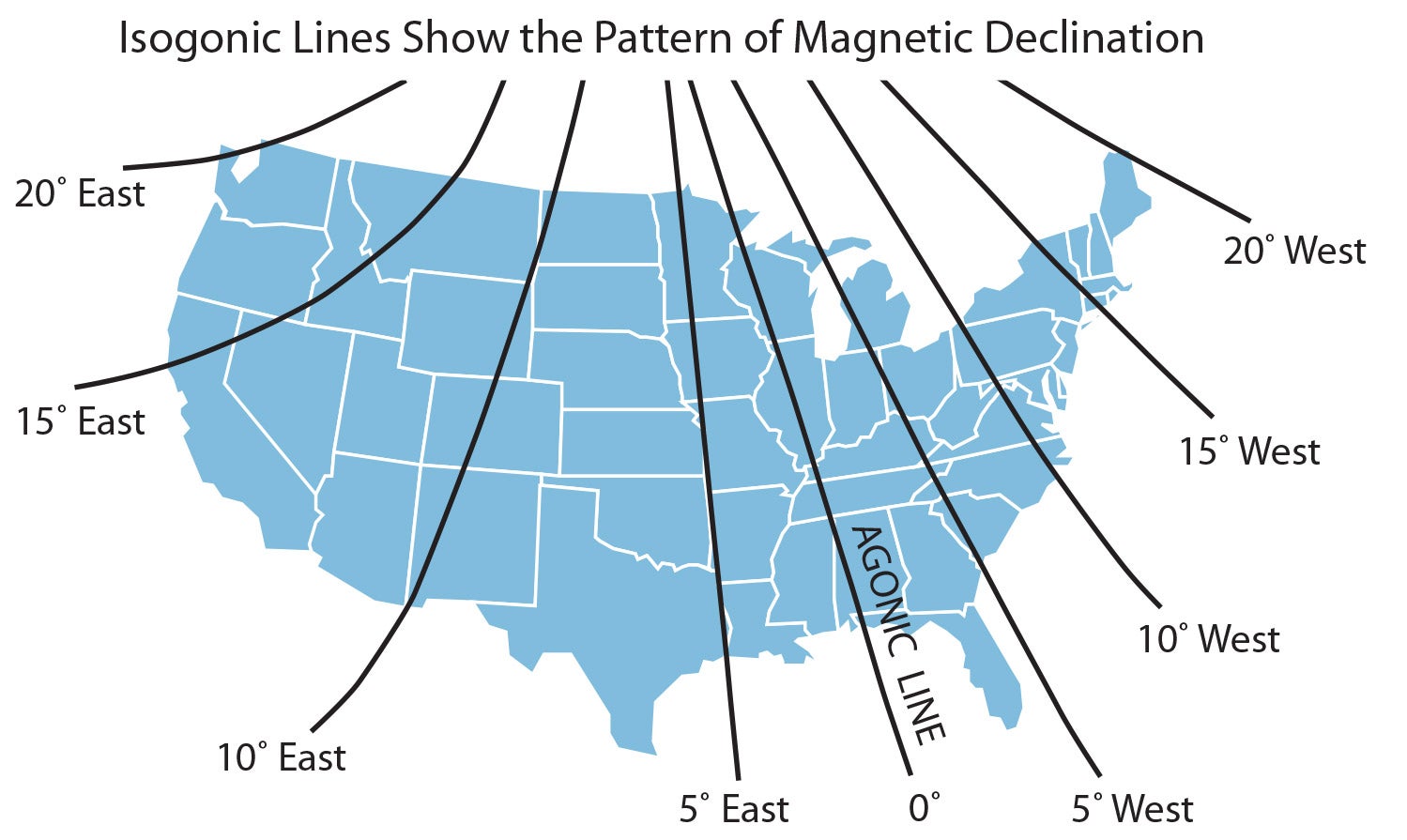
When I was first learning to fly (using pterodactyls with saddles), magnetic north was in Greenland. It has since migrated to eastern Canada since that liquid iron ball in the center of the earth keeps moving around. There is a line that you need to know about…the agonic line. This is the straight line that goes from the Santa Claus north pole, through Greenland’s magnetic north pole, through the Wisconsin Dells, through St. Louis, through Nashville and through Alabama’s Maxwell Air Force Base. This line lines up the magnetic north pole with the true north pole. No correction necessary.
For those of us east or west of the agonic line, there are corrections necessary to use a compass to find true north. It ranges from as much as 20° east declination in Seattle to as much as 20° west declination north of Presque Isle, Maine.
The conversion from magnetic to true has a lot of ways to make these math problems rememberable: East is least and west is best. True virgins make dull company. And a few more that can’t be printed in a family magazine. And most of which we forget completely once we pass the FAA written.
It’s better to think about this logically. Here in California, at about 13° east compass declination, when I face north I picture Greenland to the right of the north pole. Therefore, my compass will point 13° to the east of the actual true north pole. I must therefore subtract 13° from my compass reading to convert compass direction to true direction. Bottom line? 360 – 13 = 347 so when I point my compass to 347°, I am pointed toward the true north pole. Subtracting 180° says that when my compass is pointed due south at 167°, it is pointed at the true south pole.
Three Rules to Remember
- 360° minus east declination = compass reading to point true north.
- 360° plus west declination = compass reading to point true north.
- True north compass reading minus or plus 180° is the compass reading for true south (whichever gives you something close to south).
 So, where do we get correct information for our airports? Unfortunately, the FAA database is way behind in these updates but www.gcmap.com/airport has all the data for every airport in the world. For example, my local airport, Nevada County Intentional Airpatch (KGOO), can be found at www.gcmap.com/airport/KGOO. (Don’t forget the K in front of the three-letter ID). Here’s the basic information:
Note that it also includes latitude 39° that we are going to have to use in the next HOG column. I’m going to give the HOG a rest for a month and answer a question I’ve been asked at least a dozen times in the past few years…how to get your iPad music into your aircraft audio system.
This is fun for me… Until then… Stay tuned…


Another fun fact of the Earth being at the Periapsis on Jan 3 (northern winter; southern hemisphere summer): being closer to the Sun, the Earth is traveling faster in its orbit around the Sun. This results in longer hours of summer daylight for Australia than we northerners experience during our Apoapsis summers; southern hemisphere summers are shorter than ours.
All this is due to Kepler’s laws of planetary motion:
https://en.wikipedia.org/wiki/Kepler%27s_laws_of_planetary_motion
Comments are closed.